Lace up your hiking boots. We’ve compiled a curated hiking guide for the San Diego County area with 30 trails and routes to help you plan your next adventure.
Note: Before heading out, we recommend checking park websites for further info, current trail conditions, and safest practices for the area.
Key: Easy = 🥾| Moderate = 🥾🥾 | Hard = 🥾🥾🥾
Coastal treks
Guy Fleming Trail, Torrey Pines State Natural Reserve
- Difficulty: 🥾
- Length: ⅔-mile loop
- Pet-friendly: No
If you’re looking for a quick hike with panoramic ocean views to try with the kiddos, this is your trail. The path features two scenic overlooks and lots of wildflowers, cacti, ferns, and rugged sandstone cliffs. The daily general admission parking fees range from $10 to $25.
Sunset Cliffs Natural Park, Sunset Cliffs Boulevard, Point Loma
- Difficulty: 🥾
- Length: 1 mile, out and back
- Pet-friendly: Yes
Sweeping views of the Pacific Ocean await at this coastal trail perfect for walking or jogging. If you’re lucky (and if it’s up and running), you might even find the hidden swing. Pro tip: Get there early to find overlook or street parking, as this is a popular spot. Stay only on the marked path and follow all posted safety signs — the cliffs can be unstable.

The Bayside Trail in Point Loma is truly breathtaking.
Photo via @walker.photos_nyc
Bayside Trail, Cabrillo National Monument
- Difficulty: 🥾🥾
- Length: 2.5 miles, out and back
- Pet-friendly: No
This stunning trail begins northeast of the Old Point Loma Lighthouse and follows a former military road that winds down from the top of the park toward San Diego Bay. Hikers love this path for its incredible views of Ballast Point, downtown San Diego, and Coronado Island. On a clear day, you might even see Tijuana and the mountains of Mexico to the south. Fees: $20 per vehicle, or $10 per person to enter on foot.
La Jolla Coast Walk Trail, Begins at The Cave Store
- Difficulty: 🥾
- Length: 0.6 miles, out and back
- Pet-friendly: No
This gorgeous trail along the bluffs of La Jolla’s coastline can be accessed near the historic Cave Store and Sunny Jim’s Sea Cave off Coast Boulevard or off Torrey Pines Road north of Prospect Street. Though the trek is short, it’s breathtaking — and quite historic — offering views of the Pacific Ocean, kayakers, and local wildlife. There’s not a lot of shade, so wear sunscreen and a hat.
Coastal Trail, Cabrillo National Monument
- Difficulty: 🥾🥾
- Length: 1-mile, out and back
- Pet-friendly: Yes
Located on the west side of the Point Loma Peninsula, this trail leads to the tide pool access area and is popular with families. The trek does have some steep slopes, but the amazing views are your reward. Keep an eye out for interesting native vegetation that thrives in the coastal environment like rare, yellow Sea Dahlia.
Oceanside Trail, Cabrillo National Monument
- Difficulty: 🥾🥾🥾
- Length: 2.5 miles with significant elevation gain
- Pet-friendly: No
Cabrillo’s newest trail debuted in April 2024 with breathtaking ocean views. To access this path, start at the top of the Whale Watch & Kelp Forest Overlook trail. This trail transcends the bluffs and connects to the Coastal Trail. With steep areas, steps, switchbacks, and significant elevation gain, the park considers this hike is strenuous but beautiful.
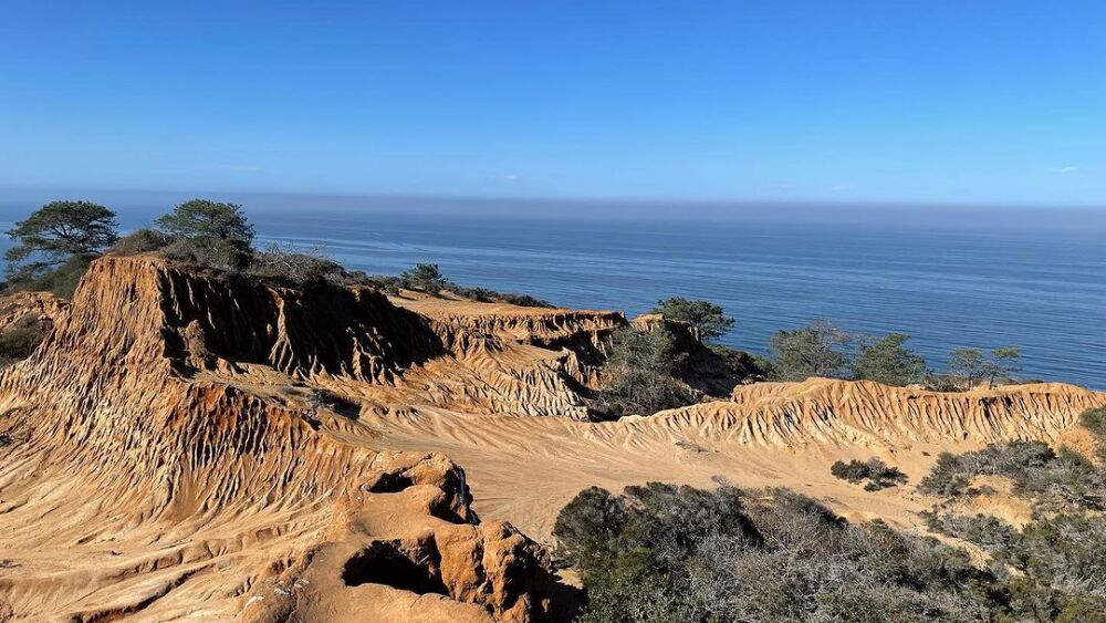
Yep, we’d say Broken Hill is worth every step.
Photo via @lupercioci
Broken Hill Trail, Torrey Pines State Natural Reserve
- Difficulty: 🥾 🥾
- Length: 3.3-mile loop
- Pet-friendly: No
Expect an elevation gain of 390 ft during this moderately challenging trek — but we think the incredible views of the ocean and eroding sandstone are worth every step. This is the reserve’s longest trail through chaparral and sagebrush. Parking fees range between $10 and $25.
Ocean Front Boardwalk, W. Mission Bay Drive at Ocean Front Walk
- Difficulty: 🥾
- Length: 5.9 miles, out and back
- Pet-friendly: Yes
Soak up the sun in Mission Beach and Pacific Beach on this paved path beloved by both locals and tourists. The boardwalk averages at 8 ft wide and there are accessible bathrooms. Pro tip: Get there early in the morning to beat the beach crowds.
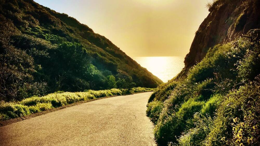
The Black’s Beach Trailhead, with sunset on the horizon.
Photo via @felipe_oranch
Black’s Beach Trailhead, La Jolla Farms + Blackgold roads
- Difficulty: 🥾 🥾
- Length: 1.1 miles, out and back
- Pet-friendly: Yes, leashed — hours restricted to before 9 a.m. and after 6 p.m.
This partially paved trail starts downhill, leading to Black’s Beach — San Diego’s nude beach. Surfers take this trek to get to the waves, which are notoriously gnarly at this shoreline.

The Encinitas portion of the Coastal Rail Trail.
Photo via SANDAG
Coastal Rail Trail, 1298 S. Coast Highway 101, Encinitas
- Difficulty: 🥾
- Length: 1.3 miles, out and back
- Wheelchair accessible
- Pet-friendly: Yes, leashed
The Encinitas portion of this major coastal project opened in May 2019 and features a paved walking and biking path along the east side of the railroad tracks near San Elijo Avenue. When the ultimate vision for the Coastal Rail Trail is completed, it’ll span 44 miles from Oceanside to downtown San Diego.
Carlsbad Sea Wall Trail, Carlsbad State Beach
- Difficulty: 🥾
- Length: 1.4 miles, out and back
- Wheelchair accessible
- Pet-friendly: No
Take in views of Carlsbad State Beach, Tamarack State Beach, and the Pacific Ocean along this paved, picture-perfect path. Pro tip: This is a good one for the kids, but leave the pups at home.
Picture perfect views
Embarcadero to Spanish Landing, Embarcadero
- Difficulty: 🥾
- Length: 7.7 miles, out and back
- Pet-friendly: Yes
This popular walking and jogging path offers views of San Diego Bay and the downtown SD skyline, plus grassy areas to sit and take a break. You’ll also pass through Seaport Village — a perfect excuse to grab a snack or beer at the landmark.
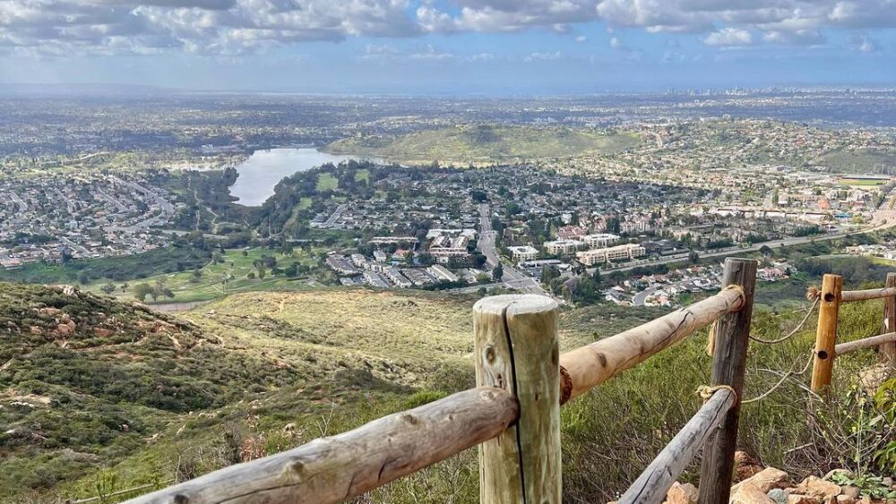
Cowles Mountain is an uphill challenge, but the views are epic.
Photo via @cal.euphoria
Cowles Mountain, 7001 Golfcrest Dr., San Carlos
- Difficulty: Moderate = 🥾🥾
- Length: 3 miles, out and back
- Pet-friendly: Yes, leashed
The elevation gain gets up to 1,593 ft and the path can get steep and rocky near the summit, but the breathtaking views at the top are worth it. The trailhead starts at the corner of Golfcrest Drive and Navajo Road; there’s a parking lot and street parking but it does fill up quickly, so get there early. There are also several other access points: Cowles Service Road, Big Rock Park, Mesa Road, and Pyles Peak Summit.
Otay River Valley Trail, Otay Valley Regional Park
- Difficulty: 🥾
- Length: 8 miles, out and back
- Pet-friendly: Yes, and may be off-leash in some areas
This trail is part of the park’s 8.3 miles of multi-use trails and popular among hikers and mountain bikers. Otay Valley Regional Park is one of the major open space areas within San Diego County — and the county hopes to one day extend this trail system.

he varied habitats of Los Peñasquitos Canyon Preserve Trail are home to diverse wildlife, flora, and fauna.
Photo via @lorishort
Wildlife walks
Famosa Slough, West Point Loma Boulevard
- Difficulty: 🥾
- Length: 0.7 miles, out and back
- Pet-friendly: Yes
This 37-acre Marine Conservation Area is teeming with wetland life. Get into nature and help restore this fragile ecosystem at one of the Friends of Famosa Slough’s work parties, take a guided nature walk, or just stroll through and appreciate a one-of-a-kind biome in the heart of San Diego.
Los Peñasquitos Canyon Preserve Trail, 12020 Black Mountain Rd., Rancho Peñasquitos
- Difficulty: 🥾
- Length: 6.8-mile loop
- Pet-friendly: Yes, leashed
This trail is popular for hiking, mountain biking, and birdwatching. The preserve features many geological formations, soil types, and water sources — including a waterfall cascading through volcanic rock and a freshwater marsh. The varied habitats are home to diverse wildlife, flora, and fauna. Check out this map of the main trail, and then some.
San Elijo Lagoon Nature Center Loop, San Elijo Ecological Reserve and Nature Center
- Difficulty: 🥾
- Length: 0.6-mile loop
- Wheelchair accessible
- Pet-friendly: Yes, leashed
Perfect for a quick nature walk, this loop offers views of birds foraging in salt marsh and mudflat habitats. You’ll spy lots of interesting, native wildlife at San Elijo Ecological Reserve — from ospreys and great egrets, to the pygmy blue butterfly. Pro tip: If you have extra time, the reserve has 7 more miles of trails to explore.
Otay Lakes County Park Loop, 2270 Wueste Rd., Chula Vista
- Difficulty: 🥾
- Length: 1.5-mile loop
- Pet-friendly: Yes, leashed
This trail — beloved by birdwatchers — offers beautiful views of Otay Lake and its surrounding hills. The 78-acre park opens daily at 9:30 a.m.; parking costs $3.

The Mother Miguel Mountain hike reaches elevations of up to 1,040 ft, with views like this.
Photo via @ducktriumph
Mother Miguel Mountain Trail, 345 Paseo Los Gatos, Chula Vista
- Difficulty: 🥾🥾
- Length: 4.5 miles, out and back
- Pet-friendly: Yes, leashed
This hike has rapid elevation change — up to 1,040 ft at its highest point — and the path can get steep. At the peak, you’ll be able to see Sweetwater Reservoir, the Salt Creek Golf Course, and all of the South Bay, plus downtown San Diego, San Diego Bay, Coronado, and Mexico. Fun fact: This trail is home to the Quino checkerspot butterfly, the coastal California gnatcatcher, and Otay tarplant, rare species that the US Fish and Wildlife Service is required to protect.
Horse to South Beach Trail Loop, Border Field State Park, Imperial Beach
- Difficulty: 🥾
- Length: 3.1-mile loop
- Pet-friendly: No
This trail runs through the Tijuana River National Estuarine Research Reserve, one of just 30 reserves in the US, and near International Friendship Park. The Tijuana Estuary — located on the US-Mexico border — is the largest coastal wetland in Southern California and home to a wide array of wildlife including birds, mammals, reptiles, amphibians, fish, and invertebrates. Access to the hiking and biking trails is free and portions of the park are wheelchair accessible; check out this map.
Best for a workout

The climb is a fun part of Annie’s Canyon Trail.
Photo via @brandycarper
Annie’s Canyon Trail, 498-450 Solana Hills Dr., San Elijo Lagoon
- Difficulty: 🥾
- Length: 2.2-mile loop
- Pet-friendly: Yes, leashed — but no dogs allowed in the slot canyon portion
This slot canyon hike is beloved by locals for its gorgeous views of San Elijo Lagoon and its one-of-a-kind path through narrow sandstone walls. As you walk, it feels as though the walls are hugging you. Portions of the path feature ladder-style steps and you will need to use your hands to climb up, and the trail has an elevation gain of ~473 ft, making for a nice little workout.

Once you make it to Potato Chip Rock, snapping a fun pic is essential — and we bet you can’t take just one.
Photo via @simplyy_denise
Potato Chip Rock, Mount Woodson (between Poway + Ramona)
- Difficulty: 🥾🥾🥾
- Length: 7.3 miles, out and back
- Pet-friendly: Yes, leashed
This famous trail leads to a rock formation shaped like a potato chip — a favorite place among hikers to snap a photo, sometimes while actually eating chips on the rock (hey, you earned it). The elevation gain is ~2,109 ft with many switchbacks, and the hike takes about 4.5 hours to complete. Bring plenty of water for this one.
Sixth & Upas Trails Gateway, Balboa Park
- Difficulty: 🥾🥾
- Length: Five trails ranging from 1.5 to 6.6 miles
- Pet-friendly: Yes, leashed
Walk over to the northwest side of Balboa Park to access this network of five trails fit for any kind of workout. Our favorite path is the 4.1-mile trail that takes you past the landmark’s museums + gardens — just follow the No. 2 light orange trail markers.
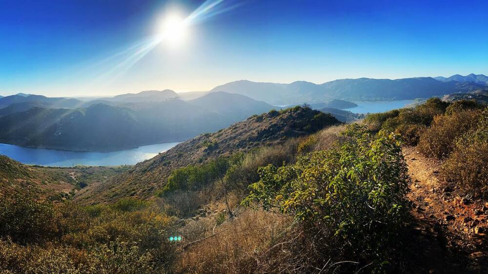
The view from Bernardo Mountain Summit in Escondido.
Photo via @jessamine15
Bernardo Mountain Summit Trail, San Dieguito River Park, Escondido
- Difficulty: 🥾🥾🥾
- Length: 1.95 miles, out and back
- Pet-friendly: Yes, leashed
Part of the larger Coast to Crest Trail system, this path — with its elevation gain of ~889 ft — is known for its epic, 360° views of Bernardo Mountain, Lake Hodges, Escondido, and Rancho Bernardo. There are several staging areas you can use to access the trail, including the area at 12655 Sunset Dr. From there, you take the Coast to Crest Trail for 1.73 miles to the Bernardo Mountain Summit Trail, just after crossing Felicita Creek.
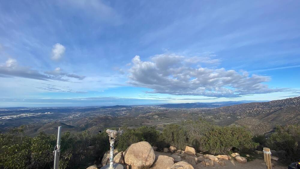
Iron Mountain is a moderately challenging trek with many switchbacks.
Photo via @carterschoon_photo
Iron Mountain Trail, state Route 67 at Poway Road
- Difficulty: 🥾🥾
- Length: 5.9 miles, out and back
- Pet-friendly: Yes, leashed
This dirt trail starts off relatively flat but about half-way through, the switchbacks begin with elevation gains of up to 2,660 ft at the top. The portion to the peak is steep and rocky, so sturdy footwear is a must. Hikers can also reach the Wildwood Mountain and Ellie Lane trails from this path.
El Cajon Mountain, El Capitan County Preserve, Lakeside
- Difficulty: 🥾🥾🥾
- Length: 11 miles, out and back
- Pet-friendly: Yes, off-leash in some areas
Arguably the most strenuous hike in San Diego County, this challenging route at El Capitan County Preserve has an elevation gain of 3,579 ft with many steep, rugged ascents as you get closer to the summit. This is an all-day hike that requires solid shoes, lots of water, and determination. County of San Diego Parks and Recreation hosts its Warrior Hike Challenge on this path each November, a popular event among active and retired military service members. Reminder: El Capitan County Preserve is usually closed every August due to hot weather.
Mission Trails
North Fortuna Mountain Trail via Grasslands Crossing, Mission Trails Regional Park
- Difficulty: 🥾🥾🥾
- Length: 3-mile loop
- Pet-friendly: Yes, leashed
This loop has an elevation gain of ~1,198 ft and offers lots of opportunities for bird watching. Branch off and enjoy other parts of the Fortuna region, too. Mission Trails boasts 65 miles of trails spanning 8,000 acres, so there’s a lot to explore.
Grasslands Loop Trail, Mission Trails Regional Park
- Difficulty: 🥾
- Length: 1.2-mile loop
- Pet-friendly: Yes, leashed
This relatively flat path is perfect for a quick hike with kids, and easily accessible via the park’s East Fortuna Staging Area at the intersection of state Route 52 + Mast Boulevard in Santee. There are a couple of small parking lots here, too.
Father Junipero Serra Trail, Mission Trails Regional Park
- Difficulty: 🥾
- Length: 4.5 miles, out and back
- Wheelchair accessible
- Pet-friendly: Yes, leashed
This paved trail cuts through the picturesque mountains of Mission Trails and is great for hikers and cyclists of all ages. Pro tip: Take a quick detour to hike down to the historic Old Mission Dam — it’s a great place to relax and listen to the water.
Lake Murray Trail, 5540 Kiowa Dr., La Mesa
- Difficulty: 🥾
- Length: 5.7 miles, out and back
- Wheelchair accessible
- Pet-friendly: Yes, leashed
This paved trail offers views of Lake Murray Reservoir and is popular among hikers, joggers, and cyclists. There are paths leading down to the lakeshore, and some benches along the way. When you get to the fence at the end of the path, be sure to touch the bullseye sign — every local knows, you haven’t truly completed this hike until you tap it for good luck.
Psst: This is just a sampling of the many incredible hiking trails in San Diego County. Did we miss your favorite? Send us a note and we may include it in our next hiking roundup.
Get the right gear
Get the most out of your trip with comfortable, handy, and helpful hiking gear:
- For the best footwear, check out Nordstrom Rack’s sneaker edit for hiking.
- If your trail demands a proper hiking boot, we like Columbia’s collection on Amazon.
- Travel light (but still have room for snacks) with lululemon’s Everywhere Belt Bag.
- Get a good bulk deal on Perfect Bars, Clif Bars, or Kind Bars at a warehouse store like Sam’s Club.
- Don’t forget to bring a compact, portable phone charger (you’ll thank us later).
- We like this Teton hiking backpack.
- We like this lightweight water bottle.
- Psst — to be ultra-prepared, here are the 10 items you should never enter a national park without, according to the National Park Service.


